Saturday, February 27, 2016

Land of the Dragons: Komodo Island

Come not between the dragon and his wrath.”  William Shakespeare, “King Lear”

The world’s largest breed of lizard is also the most dangerous:  the komodo dragon. National Geographic says, “As the dominant predators on the handful of islands they inhabit, they will eat almost anything, including carrion, deer, pigs, smaller dragons, and even large water buffalo and humans.”

The male dragons can get as large as 300 pounds, and the females about half that.  They have tremendously large and powerful jaws.  A dozen of them can take down a water buffalo in a matter of minutes.  Or a human.  But deer are apparently their favorite food.  They also will eat one another, and it’s not uncommon for a male to eat the eggs fertilized by another male.  Since the mother lays the eggs and then guards the nest for only part of the gestation period, the eggs can be particularly vulnerable. Newborns are similarly vulnerable, since by the time they hatch the mother is long gone and they are on their own. And their biggest threat is their own kind.

Komodo Island, the place that we visited yesterday, is their primary habitat, though they can be found on three other nearby islands. Apparently they have a very acute sense of smell, and are particularly attracted to the smell of blood (land shark, anyone?).  So we were instructed ahead of time that no one with open sores should go ashore, nor anyone menstruating. Also, no one would be allowed to wander alone on the island, because of how dangerous these animals can be.  

And, if a dragon comes after you, forget climbing a tree to get away—the younger ones are good climbers.  And don’t try going in the water—you’re likely to encounter them swimming as well.

Not surprisingly, these cautions left us with a bit of foreboding, but 700 of the approximately 900 people on the ship went ashore, so there was not enough concern to stop us from this unique experience. 

Once ashore, we were assigned to groups of about 20, with each group having three local escorts: a naturalist who walked at the head of the group carrying the “defense weapon” (a stick with two prongs on the end--check what's in the ranger's hand in the photo below), and watchers in the middle and at the back of the group.  We were instructed to talk quietly, if we must talk at all, and not to dangle anything (cameras, jewelry, purses, etc), or use flash on our cameras.  In other words, do nothing to attract their attention.


We proceeded to walk a trail of about a mile through the place where the komodo dragons roam.  We’d no sooner started than we spotted a young dragon across a ditch.  Alas, I was unable to get a good photo of him, even though he stopped periodically and struck a pose.  According to the naturalist, he was likely checking the area for threats or food.

That was the last dragon we would see, until we reached a watering hole, where about eight of them were lounging.  There was only one female among them; the rest were the larger males.  Our guide informed us that all the dragons there were likely “middle aged”—40 years old, give or take.  Life spans of komodo dragons can vary depending on food supply. The average is 57, though they can live as long as 80 years or more.


Of course, someone had to ask:  have they ever lost a human to a komodo dragon?  The guide’s tactful answer:  “it has happened.”  So, when was the last attack on a human?  The last one he knew about was two years ago, on another of the islands where they live (and, in fact, the island where he lives).  That person survived, and was airlifted to a hospital in Bali.

At the end of the day, the ship’s captain happily announced that all who had gone ashore had returned to the ship, and all with limbs intact.  It was one of the more interesting days.

As I write this, we are within sight of Bali, having essentially been circling it all morning. We were initially scheduled to dock this morning, but were unable to sail in because of the direction of the currents and the level of the tides.  We expect to dock in about two hours, meaning our three scheduled days in Bali are now two and one half days.  Fortunately, the guide we’d lined up for today was able to accommodate us tomorrow, so we’re looking forward to an exploration tomorrow.


Thursday, February 25, 2016

The Top End of Australia: Darwin


 “Alone of all the races on earth, they seem to be free from the 'Grass is Greener on the other side of the fence' syndrome, and roundly proclaim that Australia is, in fact, the other side of that fence.” ~ Douglas Adams


After visiting urbane cities like Sydney and Brisbane, I’d started to wonder if the stereotypical outback Aussie was just a myth.  Then we got to Darwin, Australia’s northernmost city—one set apart from the rest of the country by the vast outback that divides it and the rest of the country. 

Which is not to say it is not a city: though the population is relatively small (about 120,000), it is cosmopolitan and modern.  It is the capital of the Northern Territory, which is comprised primarily of desert and cattle stations, and is very sparsely populated.  The Northern Territory is just that—a territory, not a state—and as such is rather like Washington, DC or Puerto Rico in the U.S.  The people of Darwin seem to take pride in their independent spirit but somewhat resent their relative isolation from the rest of the country.

Before coming to Darwin, I had very little knowledge of its history.  As the gateway to the outback, it is where the massive cattle stations bring their herds for export to Indonesia and southeast Asia.  It is the cows themselves that are exported, not their meat.  This is because, for Indonesia, they must be butchered in a manner that meets halal standards and, for southeast Asia, lack of refrigeration means that the meat must go immediately to market after butchering.


Darwin's skyline

Darwin also is the city that came under Japanese attack in WWII.  In fact, it was bombed 64 times during the course of the war, and was pretty much the only spot in Australia that came under bombing.  The first two attacks occurred on February 19, 1942—just 10 weeks after the bombing of Pearl Harbor.  Like Pearl Harbor, the attack came as a surprise, and the city’s defenses were unprepared for it.

The morning attack hit some U.S. navy ships that were in harbor, but most of the targets were civilian.  The noon attack targeted the airport.  Of the casualties that day, most were American sailors, followed by civilians, and then Australian military.  Representative of those killed were the nine people working in the post office, which took a direct hit by a bomb.

The history of Australia in WWII (and Viet Nam) is recorded and commemorated in a very effective and affecting museum.  Interestingly, there is a sign on entry to the museum notifying aboriginals and Torres Strait Islanders that the names of the deceased will be given.  Apparently, it is taboo in those cultures to state the names of the departed—they are instead referred to as “no-name.”

Also interestingly, many Australians are unaware of this history, and do not know that Australia came under bombing in WWII.  According to our guide, a retired police officer who now serves on the Darwin city council, it is rarely taught in Australian schools.  There seems no small amount of resentment over this, which seems to feed the culture of separateness from the rest of the country.

It is not just war that has devastated Darwin.  It also is highly subject to cyclones (hurricanes), and has been destroyed three times by that severe weather, most recently in 1975.  On the theme of separateness, we were told that it took a long while to recover, as there were no nearby populations to come to their aid.

Darwin also comes under another threat.  It has only two seasons:  wet and dry.  They are currently in the wet season, which runs October to April.  As there is zero rain during the dry season, the city relies on “the wet” for its water supply.  Unfortunately, this year’s wet season is the driest in memory, and thus there is great concern about the water supply.

Our departure from Darwin also marks our departure from Australia, as our ship is now bound for the “Far East.”


Next up:  Komodo Island, Indonesia

Tuesday, February 23, 2016

If It’s Tuesday, This Must Be Thursday*: Australia’s Northern Islands, and the Great Barrier Reef

 “[Australia] has more things that will kill you than anywhere else. Of the world's ten most poisonous snakes, all are Australian. Five of its creatures - the funnel web spider, box jellyfish, blue-ringed octopus, paralysis tick, and stonefish - are the most lethal of their type in the world..”Bill Bryson, “In a Sunburned Country

We have left behind Australia’s more populous southeastern cities, and have the Gold Coast in our rear. We are now in the sparser northern territory, having spent the past couple of days on or near the Great Barrier Reef, the world’s largest living object, and a thing visible from space.

If you want to see the Great Barrier Reef, do not do it via cruise ship.  Beth and I were there in 2010, and stayed in a coastal town called Palm Cove.  We used Port Douglas as our jumping-off point and caught a dive/snorkel boat from there to go to several different spots on the reef.  It was spectacular.  See my blog of that trip.

This time, we arrived Sunday morning in the Whitsunday Islands, in a town called Hamilton, where people who wanted to snorkel could catch a boat out to a pontoon some two hours away.  There, they and several hundred others snorkeled or dived to see a reef that is in distress.  Most who went came back disappointed.  Unfortunately, because of our brief time in the area, that truly was the only opportunity to see the reef, and they were unable to go to the parts that are still vibrant.  For my part, I wandered around Hamilton, a pretty little resort town with nice views and a decent beach, since I already was aware of the realities of the snorkel trip being offered.                                                            

On Monday, the ship “cruised the Great Barrier Reef.”  While of course one could not see the reef itself from a ship, we could at least see the shades and shadows of the waters and islands, which in themselves were mesmerizing.  Shades of blue I have never seen segued into other shades of blue both serene and spectacular.

The next day, we were scheduled to visit Thursday Island, a remote island 1.3 square miles in size and having a population in the neighborhood of 2,000.  Situated north of mainland Australia’s northernmost point, it is a last stop in Australia en route to Papua New Guinea (to which we are not going—we still have one more Aussie port).  It was of strategic importance during World War II, and of interest from that perspective and because if its pearl diving history.

But, alas, our Tuesday in Thursday was not to be.  We arrived in rainy weather and choppy seas, and dropped anchor a distance off the island, with the notion that we would tender over to the island.  Our own tender boats (which actually are the life boats) were too small for this task, so the island sent over a couple of ferries.  Unfortunately, the seas were too rough for the ferries to come alongside the ship, so after about 45 minutes of trying, the captain gave up and set sail for the next port. 

Our missed visit to Thursday Island was likely more disappointing to the island’s handful of merchants than to any of us, as 800-900 people from a cruise ship can bring a nice infusion of cash, however brief the visit.


Next up:  Darwin, Australia

*Confession: I stole the title from the onboard newsletter, which of course in turn stole it from the old movie.

Friday, February 19, 2016

Up in the Down Under: Sydney and Brisbane

“Australia is not very exclusive. On the visa application they still ask if you’ve been convicted of a felony – although they are willing to give you a visa even if you haven’t been.” ~ P.J O'Rourke, “Holidays in Hell”

Sydney—particularly the Sydney Harbor—is beautiful.  The Opera House, Circular Quay, and the skyline in general all seem at once familiar and spectacularly fresh.

As this was my second time in Sydney, I passed on the usual tourist spots in the city.  Instead, the first day was spent with our friend Lee who lives just outside the city and graciously spent her day coming into town and visiting us on the ship.

On the second day, I boarded a bus to the infamous Blue Mountains, filled with beauty, fresh air, and charming towns.  On the way, we stopped at a wildlife park to visit with animals native to Australia.  Interestingly, the park is ringed with private homes.  I’m not sure I’d want to hang out my washing right next to the dingo enclosure, but indeed there was the laundry, downwind from all the scents the animals leave.

We then arrived in the mountains, and boarded the world’s steepest train, riding down at about a 90 degree angle, to a valley to view some fascinating flora.  Then, taking a tram back up top, we had magnificent views of the mountains, including the “three sisters”—limestone outcroppings of significance to the indigenous people and an iconic landmark to other Australians.

That evening, Beth and I enjoyed some wine on our balcony as we watched the Sydney skyline light up, and our ship sail off at 10:00 pm.  Farewell, lovely Sydney.

Our next stop was Brisbane, gateway to the gold coast.  Brisbane itself was interesting—a very clean city with, at least to my eye, no unifying architectural character, other than the fact that much seems to have been built to make most advantage of river views.

This was another wildlife viewing day, as Beth and I went off to a koala sanctuary, which also was home to a number of other Australian animals. There was an “opportunity” to hold a koala, which we passed on, both because of a long line and because of some uncertainty as to whether such things are good for the animals.  But we did see a number of koalas—yes, they are adorable—as well as quite a lot of kangaroos, and even a platypus (the latter being hard to spot).  The day was exceptionally hot and humid, but also wonderful.

Australia is fascinating in so many ways, not the least of which is that the vast majority of the land mass of the country is either sparsely inhabited or uninhabited.  Indeed, 97% of the populace live in metropolitan areas along the coast. 

Most Aussies we meet are friendly and outdoorsy, thus meeting the stereotype, but few are “outback rugged,” notwithstanding movies like Crocodile Dundee. There are quite a few Aussies on the ship, and we’ve made good friends of several, but I haven’t noticed any of them with long knives.

Mama kangaroo with joey in pouch.

Next up:  The Great Barrier Reef


Saturday, February 13, 2016

More Nations of Islands: Vanuatu and New Caledonia

“I'm off to an island nation where formal wear consists of a leaf tied around a penis.” ― J. Maarten Troost, “Getting Stoned with Savages: A Trip Through the Islands of Fiji and Vanuatu” *

Inyeug, the indigenous name for what we know as Mystery Island, is an uninhabited island that lies less than half a mile from the larger, and well-inhabited, Aneityum. Both are among the 80+ islands that comprise the nation of Vanuatu. 

Supposedly the reason for the lack of residents is that the island is reputed to be haunted, with the ghosts coming out only after dark.  Despite the lack of residents, there was not shortage of people on the island the day we visited. They come over from Aneityum to sell crafts and operate concessions, such as renting snorkel gear, giving boat tours, and providing the “opportunity” to be photographed in the “cannibal soup” pot.  And, yes, there were toilets, as well as plenty of huts for shade.

But this island was all about the beach.  Post-card pretty, its sand was perfect and the water the ideal temperature for an extended swim. (Actually, the tiny island boasted several lovely beaches—this is just the one that I swam in.)  These waters occupied most of my time on the island.

The other interesting part of the island was its air strip.  Built during WWII, it is still in use today, as we watched a small turbo-prop take off just as we were arriving.


Next up was Mare Island, in the nation of New Caledonia. I will confess that I missed this one, as I was feeling a bit under the weather that day, and wanted to make sure I was well for the next day.  Mare Island is larger than our little deserted island in Vanuatu, and boasts a population of about 5,600.  The ship had set up only one thing: a shuttle to a beach.  Had we not had the lovely beaches on Mystery Island and Yasawa, I’m sure people would have loved this beach. As it was, the consensus from those who went seemed to be that the beach was fine, but not a stand-out.

Continuing in New Caledonia, the next day was the island of Grand Terre and its capital city of Noumea.  Its population of a bit more than 100,000 comprises 70% of the nation’s overall population.  The nation is in fact a territory of France, and its people are comprised of a mix of ethnicities, including French, Vietnamese, Polynesian, and others, but the largest plurality by far are the indigenous Kanak people.

Noumea itself is a lively, cosmopolitan city filled with restaurants of many varieties, and a ring of bike paths, exercise and playground spots, and numerous beaches.  I don’t think I’ve ever seen as many kite surfers and wind surfers in one place as there were at just one of the beaches.

An interesting visit was to the JM Tjibaou Cultural Center.  Built by the French government as a kind of apology for the colonial past, and the abuses that went with that, the Center offers an expansive history and explanation of the Kanak people and their culture.  Named for a leader of the Caledonian independence movement, who was assassinated in the 1980s, the design of the center is meant to evoke the huts that are the traditional homes of the Kanak, but are egg-shaped in homage to the culture’s honor of the origins of life. However, none of the eggs are fully formed, just as the culture is an ongoing, changing thing.

One sign of the changes is that, while many huts still stand, few Kanak people live in them now.  They preserve them as a place to relax and entertain, but have built modern houses next door, primarily for safety in light of the cyclones and other similar weather to which the island is subject.

A fact that I found interesting is that the population of Grand Terre was about 75,000 just prior to the outbreak of WWII.  At the height of the war, the population was 1.5 million, primarily comprised of Allied forces who used the island as a base for activity in the Pacific theater.

Another item of note is that the island is surrounded by the largest lagoon in the world, and protected in turn by the world’s second largest barrier reef—the largest being the Great Barrier Reef in Australia, where we will be in another week or so.


Next up: Sydney, Australia

*"Getting Stoned with Savages: A Trip Through the Islands of Fiji and Vanuatu” happens to be a selection for the onboard book club.

Tuesday, February 9, 2016

Island Nations: Samoa and Fiji (and the Super Bowl)

It is perhaps a more fortunate destiny to have a taste for collecting shells than to be born a millionaire.” Robert Louis Stevenson

The cruise has now reached the south Pacific islands phase, spending about 10 days hopping from one island to another.  The first  three have been a study in contrasts.

Samoa

First was the city of Apia, in Samoa.  With a bit of a traffic problem, and a cadre of taxi drivers happily attempting to cheat visitors (but cheerfully shrugging off when the visitors don’t fall for it), Apia is very much part of the modern world. 

Samoa has certainly shown willingness to change.  I already mentioned in a previous entry that Samoa changed sides of the international date line at the dawn of 2012.  Also, about six years ago, it also changed from driving on the right side of the road to the left side, apparently with little confusion or trouble.

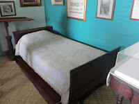
Most of my time in Samoa was spent exploring the home where Robert Louis Stevenson lived out the last 4-1/2 years of his life.  During that time, he wrote 14 novels, including some of his most famous.  Known to the Samoans as Tusitala (meaning “storyteller”), he was a respected member of the community..  He suffered ill health during his time in Samoa--largely believed to have been plagued, and ultimately killed at age 44, by tuberculosis. However, in recent years there has been some speculation that the ailment might in fact have been asthma.  Certainly if it were the latter, the extreme humidity of his adopted home could not have helped.


The bed where Stevenson wrote most of his novels in his later years.


Yasawa-I-Rawa, Fiji

This was one of the sweet surprises of the trip.  An island with a population of 600, Yasawa is a largely unspoiled place of friendly people and peaceful beauty.  Miles of lovely natural beaches are broken up only by rock outcroppings.  The people live just up from the beaches, in houses of stucco, concrete, or corrugated metal. 

This island was closed to tourism until 1987, and special permission was required to visit.  The most famous visits were by film crews:  the movie Blue Lagoon was filmed here (both a version made in the 1950s, and the 1980s stinker starring Brooke Shields). 


A morning in paradise. 
There were two things to do on this island: walk and swim.  I had not brought my swim suit, having been under the mistaken impression that the beaches were far away from where the tenders landed and hard to get to.  And because the ship was anchored offshore, and we had to tender in (i.e., take a small boat in to the island), it was not a simple matter to just go back and change clothes.  In any event, the walk along the shore was extremely pleasant, and those who swam raved about the experience.                


The Super Bowl

By the time we got back to the ship from Yasawa, the Super Bowl was in full swing.  It was being shown on large screens in a show lounge, so we joined in to cheer on the Panthers—alas, to no avail.  But it was a fun way to watch the game. 

Interestingly, the game was a live feed via the New Zealand ESPN, even though it showed the CBS commentators.  And the feed did not include the commercials.  So every commercial break brought, instead of the ads, promotions for ESPN.  The repetitiveness of the promotions brought home just how much “game time” is actually devoted to commercials.

By the way, in our time zone the game was early afternoon on Monday.

Lautoka, Fiji

Lautoka is the third largest city in Fiji, and is located on the island of Viti Levu,  Fiji itself is a nation of 333 islands, with a population of 900,000 (and growing), and with only about a third of the islands inhabited.

Lautoka is known as the Sugar City, due to sugar fields being the mainstay of its economy.  Unfortunately, the sugar market has been flattening, and so the city and the island are trying to expand other industries—including tourism—to compensate.

The Fijians we encountered were warm and friendly, with a wicked sense of humor.  The island’s cannibal history was a frequent topic of humor, as was the pervasive use of the all-purpose word, “bula” (sometimes spelled “boolah”).  It is a greeting, it is a farewell, it is a response to a sneeze, it is a toast.  It also has a multitude of other meanings.  But mostly, it is a gesture of friendship.

Our main activity on this island was at mud pools. Arriving at a site heated by volcanic pools, one of which has a current temperature above the boiling point, we were greeted by a kava ceremony, the proceeded to the pools. There, we smeared ourselves all over with mud, then strolled around the grounds while the mud dried on us.  Once it was dry, we went into a mud pool, to remove some of the mud—and re-deposit it for future use.

From there, we proceeded to a volcano-heated pool (not the boiling point one) to further wash off.  I would say completely wash off, but it may be days before that mud is completely gone from my body. 

Cleaned as I could be, I was then given a massage by one of the “mamas” of the family that runs the pool. 


A spa day, Fijian style.

Saturday, February 6, 2016

Crossing Lines: The Equator and International Date Line

"In June, the Samoan government passed a law to move Samoa west of the international date line, which separates one calendar day from the next and runs roughly north-to-south through the middle of the Pacific Ocean. Under a government decree, all those scheduled to work on the nonexistent Friday will be given full pay for the missed day of labor." -NBC News story dated 11/30/2011

Dear friends and family in the U.S.:  Yesterday our clocks were 2 to 5 hours behind yours (depending on what is your time zone), and we were to the west of you.  Today, our clocks are 15 to 18 hours ahead of yours, and we are to the east of you.  And yesterday was February 5 to us.  Today is February 7.  We kind of skipped February 6 (but only kind of—see below).

Time travel?  You could call it that.  We crossed the international date line.  This is an arbitrary line on the globe, assigned in the 1800s by the British, where the day is designated to begin.  It’s all very confusing, particularly as we moved back and forth between dates yesterday. 

Our clocks and calendars indicated that it was noon on Friday, February 5 when we arrived at the port of Apia in Samoa. But we were advised that when we went ashore it would be noon on Saturday, February 6, in Apia. And when we got back on the ship, it would be Friday the 5th again.  However, when we went to bed last night (Friday) we were told to move our clocks back one hour, and that when we awoke it would be Sunday.  So we gained an hour but lost a day.  But did spend a few hours in the missing day while in Apia. Then we went back to sea and into a different day than in Apia, Samoa.  See the quote above for the reason.

Before crossing the dateline, we crossed another line:  the equator.  While, in that moment when we crossed the line we went from winter to summer, we saw no change in the weather.  It’s just hot.

But when a ship crosses the equator, a strange ceremony occurs to mark the occasion.  It involves “Kind Neptune” (in our case, the World Cruise Hostess, Stacie, dressed as Neptune) and the “Judge” (the cruise director, Rick, so garbed), passing sentence on the “pollywogs”—anyone aboard who has never crossed the equator before. 


On sailing vessels of old, pollywogs would be tormented some, then made to kiss a fish, then thrown overboard.  On cruise ships, the tormenting is minimal, the fish is still kissed, and they are thrown in the swimming pool (which at that point has been colored by various gross-looking fluids). 

For a variety of reasons, our ship skipped the torment and the pool-toss, keeping only the fish-kissing.  Beth and I were spared even that, as we had crossed the equator before (and thus were aware of the usual proceedings).  But they added some fun entertainment—dancing, singings, comedy, etc.  It was a lot of fun, and the crew seemed to have a great time acting goofy.


 Once all the lines were crossed, we celebrated with an Elvis-themed evening.  Because, well, why not?  The dinner menu was, shall we say, unique.  The crew was attired in the Elvis mode.  And the entertainment was, well, you can probably guess. 


Next blog:  Apia, Samoa (we’ve already been there—it was in the midst of the line-crossing, as you can see above.  But I’ll be giving it its own entry).

Wednesday, February 3, 2016

A Nation on the Verge of Extinction: Kiribati

Fiji will ensure that the people of Kiribati have a home if their country is submerged by the rising sea level as a result of climate change.” President of the Republic of Fiji, Ratu Epeli Nailatikau.  Kiribati is expected to be submerged by 2030 if the current  rate of sea level rise continues.


Picture this:  nary a child nor an adult with a device in hand. A tablet is a notebook of paper—when you can get one. There was internet for a while—last year—but it is gone now.  No electricity, except what a couple of generators can produce, and no running water. Homes are corrugated metal and/or thatch.  You eat what you can grow or catch, or what may be brought in on one of the seven ships that stop here during the course of a year. Only a handful of motorized vehicles, and a few bicycles, can be found. 

This is the island known to us as Fanning Island, and to the locals as Tabuaeran. It is part of the Republic of Kiribati (pronounced kee-ree-bahs), a group of 32 atolls and one island made of guano, in the south Pacific. It became Fanning Island to the West because of Edmund Fanning , an American captain who made the first recorded sighting of the atoll in 1798. The island was uninhabited at time.  It was annexed to Britain in 1888, and became independent as part of Republic of Kiribati in 1979.

So how did a cruise ship wind up stopping at this island of fewer than 2,000 inhabitants?  Another cruise line that runs cruises through the Hawaiian Islands used to stop here to meet regulations that require that any non-U.S. flagged ship must sail internationally, which means that at least on non-U.S. port.  Fanning Island was the closest place it could find.  However, now that ship has become U.S.-flagged and no longer needs to make that stop.  When it ceased calling at the island in 2007, it essentially destroyed the externally-based economy that it had created. In January  2010, other ships started to make it a stop on Pacific crossings to help make up for the loss.  But only four cruise ships stop each year.  Add to this three supply ships per year, and you see that this island gets outside contact only seven times each year.

                                A typical home on the island.

It is not a place that feels impoverished—just a simpler life than what we know.  The people we met were exceptionally friendly and curious about these visitors, just as we were curious about their lives.  The school day had been cut short because of our visit, as many of the children lined the “main street” (a dirt path) to greet and talk to the visitors.  Their mothers lined the port to provide a makeshift craft shop, selling primarily woven baskets and shell jewelry.

The sad and shocking part of all this is that this life is on the verge of coming to an end.  The atolls of the Republic of Kiribati are all at sea level, and as ocean levels continue to rise, it is estimated that most of the nation, including Tabuaeran, will be completely submerged in the coming two decades, with many rendered uninhabitable before then due to overly-salinated drinking water. 

While most of the islands are not without modern amenities the way that Tabuaeran is, their lives are much simpler than where they are likely to wind up.  If they find a place to wind up.  The President of Kiribati has completed a purchase of land in Fiji that will hold some of the people, but it is not clear what will happen, immigration-wise. But this land will not be a transplanted nation of Kiribati; it will be part of Fiji. 

And, for the Tabuaeranians, a way of life will be gone forever.

Next up: crossing the equator.